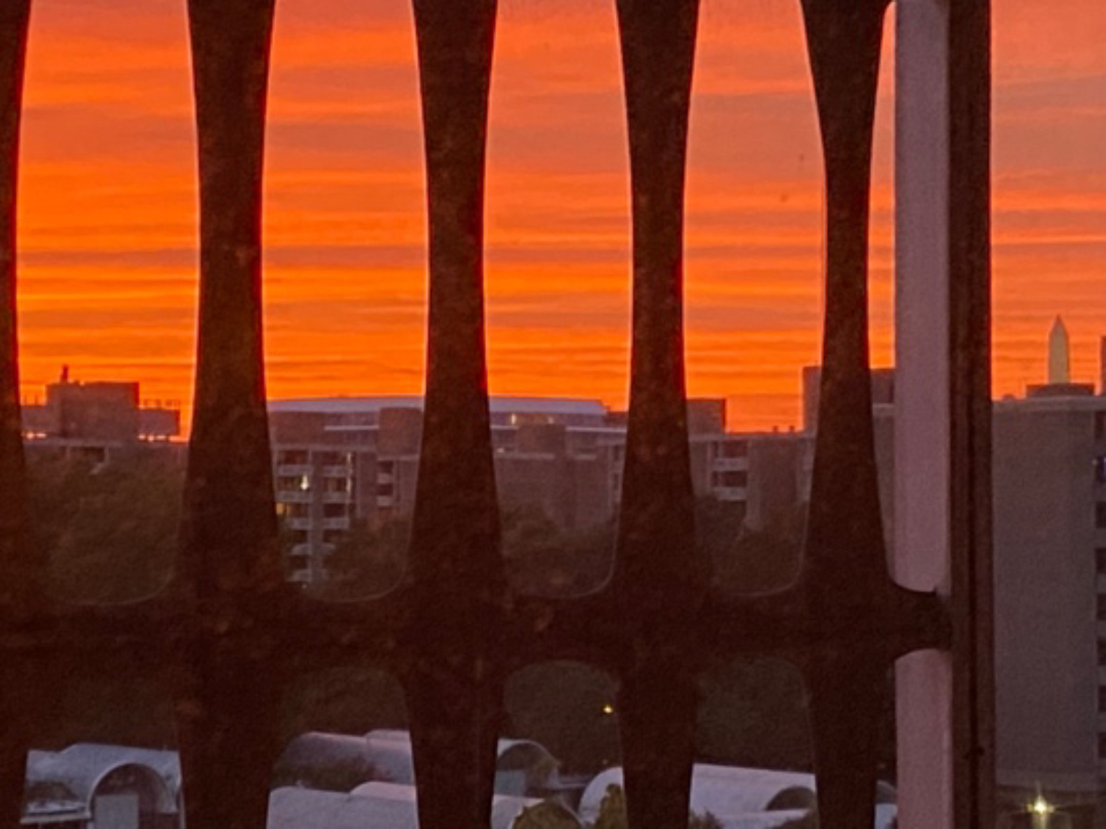
I have lived in Southwest DC for the past seven years in a 1963 cooperative housing “campus” that was built as part of the 1945 Redevelopment Land Agency (RLA). Considered to be the first formal urban renewal project in the United States, the RLA dislocated thousands of residents and their intact community of mainly Black Americans. The photograph that I was most familiar with that depicted the “before” community was the 1939 image that shows the proximity of Southwest, District of Columbia, to the U.S. Capitol Building. Many residences in the foreground were built in “alley ways” and did not have electricity, running water, or indoor plumbing.
Uncovering the Archives: Displacement in Southwest, District of Columbia 1939-2023
Author
Karol R. Wiliams, M.Arch
Affiliation
Independent scholar, architect, guest editor
Tags

Southwest Washington, D.C. in 1939 [looking towards U.S. Capitol]
Credit:
Myers, David (David Moffat), photographer, 1939 July 1, negative. Courtesy .
1940s-1950
In wanting to explore who and what was within Southwest, DC I spoke with Senior Registrar, Nancy Bateman, and Bryn Cooley, Collections Manager of the National Building Museum (NBM) Collections Department. I was very excited to learn that their Collections Department contained a never before photographed and first time digitized 5 panel painted wood on plywood model.

One panel of five panel model “Southwest Washington Before Redevelopment,” Hains Point to Canal St., Part D.
Credit:
Architectural Models Collection, National Building Museum, Condition notes: Structure is secure, however there are pieces missing/damage to building on the model. Pieces of the harbor appear to missing. Some of the letters are loose. (specifically the 'F' and the third 'E' in "Redevelopment"), Architectural Models Cataloging List, 2011.4.19d, dimensions 60”x 26”x 2’, Object ID 2011.4.19d. Photographed 9/7/2023.

Five panel model with painted title “Southwest Washington Before Redevelopment,” painted wood on plywood base, 78” x 72” x 2”.
Credit:
Architectural Models Collection, National Building Museum. Condition notes 9/6/2023: Some parts of the model are extremely fragile. Object ID 2011.4.19a through Objects ID 2011.4.19e. Accessed from AIA/AAF 4.2011. Photographed 9/7/2023.
The 78”x72”x2” model shows the existing businesses, residences and the Washington Channel in the foreground. The detailed panel of the harbor (60”x26”x2”) has a painted title in the lower left hand corner “Southwest Washington Before Redevelopment” but has no further information on the date or who commissioned it. The approximate date of the model is 1940s-1950s and when it was part of a 2011 transfer from the American Institute of Architects (AIA)/ American Architectural Foundation (AAF) to the NBM, the 6th panel was missing. I was told by Nancy Bateman, NBM, Nancy Hadley, AIA Director of Archives and Records, and Mari Nakahara, Curator of Architecture, Engineering, and Design at the Library of Congress that additional information is not known. Note in the enlarged photographs the attention to detail and extent of the community with residential rather than industrial buildings. It was interesting to see the Esso sign (last image in slideshow below) but it was very disappointing to see how many people and buildings were displaced and demolished.

Detailed bird’s eye view, residential and business buildings including painted lettering “Esso” on one structure, Maine Ave and 4th Street, Southwest, Washington, D.C., “Southwest Washington Before Redevelopment.”
Credit:
Architectural Models Collection, National Building Museum, Object ID 2011.4.19d. Photographed 9/7/2023.

Detailed bird’s eye view showing row houses with backyards and “alley way” residences, “Southwest Washington Before Redevelopment.”
Credit:
Architectural Models Collection, National Building Museum, Object ID 2011.4.19e. Photographed 9/7/2023.

Detailed bird’s eye view, “Southwest Washington Before Redevelopment.”
Credit:
Architectural Models Collection, National Building Museum, Object ID 2011.4.19e. Photographed 9/7/2023.

Bird’s eye view of five panel model, “Southwest Washington Before Redevelopment.”
Credit:
Architectural Models Collection, National Building Museum, Object ID 2011.4.19d. Photographed 9/7/2023.
The extent of demolition – and in sharp contrast to the “Southwest Washington Before Redevelopment” model – is this 1945 photo of the demolition in Southwest D.C. According to the National Capital Planning Commission’s history timeline, 400 acres were cleared resulting in the “development of new apartments and federal offices, but at the cost of the forced removal of 23,500 people and the destruction of numerous historic buildings.” Note the Jefferson Memorial, Tidal Basin, and Washington Monument in the background.

Aerial photograph Southwest, D.C., 1945, showing the clearing of “400 acres in the city's southwest quadrant that resulted in … the forced removal of 23,500 people and the destruction of numerous historic buildings.”
Credit:
, Planning History, District of Columbia Redevelopment Act (RLA).
Late 1950s
In the late 1950s high profile architects I.M. Pei, Chloethiel Woodward Smith, Charles M. Goodman and others competed for residential, business and government projects within the demolished 400 acres of Southwest. One unbuilt project, designed by Charles C. Goodman, is shown in the following model that was also photographed and digitized by the NBM for this article. It depicts a combined high rise and townhouse community between M and N Streets, and to the west 4th Street SW, D.C. The model corresponds to a drawing in the Library of Congress (LoC) Prints and Photographs Online Catalog in the Charles M. Goodman Collection. The drawing was given to the LoC in 2011 at the same time that the NBM was given the model from the AIA/AAF. I was told by Nancy Bateman that the NBM was given three-dimensional objects while drawings from the Goodman Collection were given to the LoC. At this time the project name and date is unknown.

Bird’s eye view looking from Southwest waterfront, Washington Channel. Southwest D.C. Development Model, designed by Charles M. Goodman, Architect.
Credit:
Archival Material of Charles M. Goodman, Archival Models Collection, National Building Museum, Photographed September 2023. Object ID 2014.5.47. Part of 2011 accession from AAF/AIA.

Bird’s eye view of Southwest D.C. Development Model, designed by Charles M. Goodman, Architect.
Credit:
Archival Material of Charles M. Goodman, Archival Models Collection, National Building Museum, Photographed September 2023. Object ID 2014.5.47. Part of 2011 accession from AAF/AIA.

Site plan that corresponds to unbuilt project model in image 9. [Southwest Urban Renewal, 4th St., M St., N St., O St., and Water St., S.W., Washington D.C.] [Site plan], Charles M. Goodman Associates, architect, [between 1950 and 1980], 1 drawing: reproduction, screentone, and stickers on board ; sheet 51 x 77 cm. [no title block on drawing]
Credit:

Southwest D.C. Development Model, designed by Charles M. Goodman, Architect. Unbuilt/proposed residential complex [gray roofs] bound by 6th, 4th, M and N Streets, Southwest, D.C. Entire site: K to O Streets, SW and Waterfront to Delaware Ave, SW Washington, D.C. Dimensions 27” x 15” x 2” without vitrine; with vitrine – 2.5” high. Materials: Wood, sponge, paint, plastic, metal. c. 1960.
Credit:
Archival Material of Charles M. Goodman, Archival Models Collection, National Building Museum, Photographed September 2023. Object ID 2014.5.47. Part of 2011 accession from AAF/AIA.
1960s
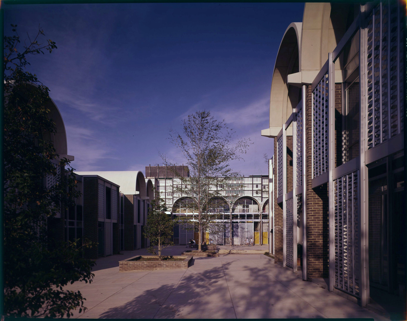
One cooperative that was built in Southwest DC as part of the RLA was River Park Homes designed by architect Charles M. Goodman and photographed by architectural photographer Robert C. Lautman. The Lautman Collection of over 30,000 images was donated as the gift of the Estate to the NBM and is still mostly undigitized. I was given access to all of the River Park photographs and a few selected transparencies are shown below. The construction photos interested me greatly but the slide transparencies of the residents who initially lived in the high rises and townhouses intrigued me more. Mr. Lautman had photographed hundreds of architectural projects but only rarely included people.

Construction photo, structural framing of barrel vaulting in foreground; Reynolds Aluminum on barrel vault roofing at background,. River Park Homes, Charles Goodman Architect.
Credit:
Robert C. Lautman Photography Collection, National Building Museum, 8”x10” transparency, c. 1961, digitized October 2023.

Construction photo, barrel vaulted townhouses in foreground; high rises in background, River Park Homes, Charles Goodman Architect.
Credit:
, National Building Museum, c. 1961, 8”x10” transparency, c. 1961, digitized October 2023.

Brochure (no date) for River Park Community, Charles M. Goodman Associates, Architects and Land Planners, Reynolds Metal Service Corp., sponsor, builder Standard Construction Company.
Credit:
River Park Homes, Charles Goodman Architect.
Credit:
Robert C. Lautman Photography Collection, National Building Museum, color transparency, 6”x 8”, c. 1963-4, digitized October 2023.
Yet, as the transparencies show, children are holding hands, playing, riding their bicycles, while older residents are conversing and pushing strollers. A similar vision was originally depicted in a 1960 rendering of the project.

Slide transparencies for publication selections: upper row - three birds eye views of River Park Community; bottom row three slides of construction transparencies.
Credit:
Robert C. Lautman Photography Collection, National Building Museum, c. 1960-63, digitized Septem